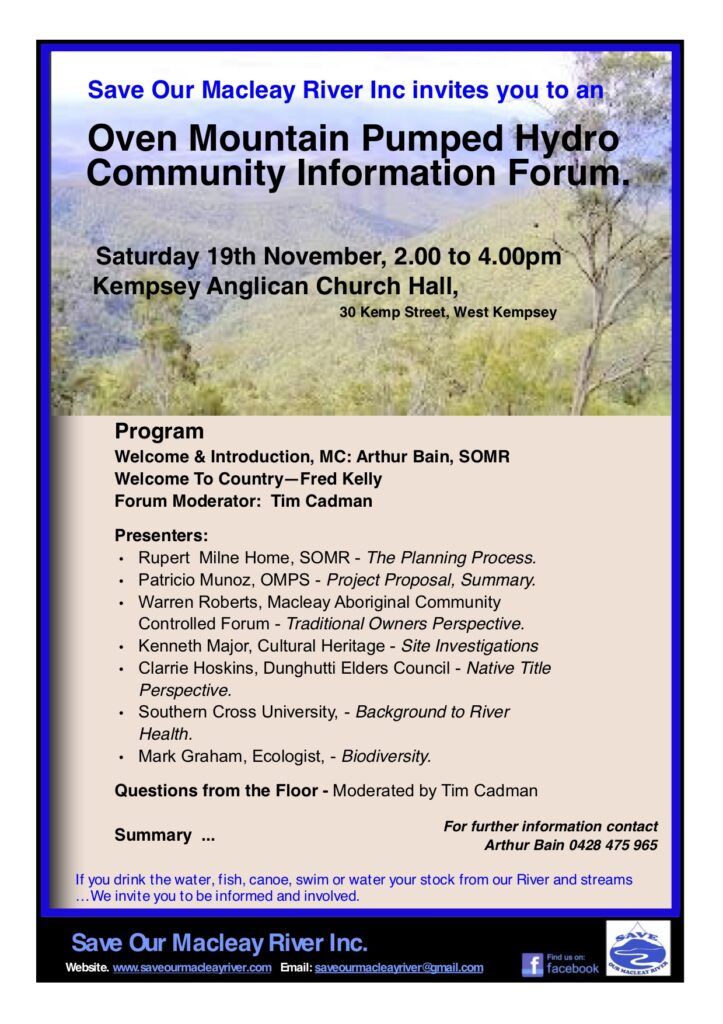
Since the last public event SOMR organised in November 2022, committee members have attended to several issues of concern.
Oven Mountain Pumped Hydro
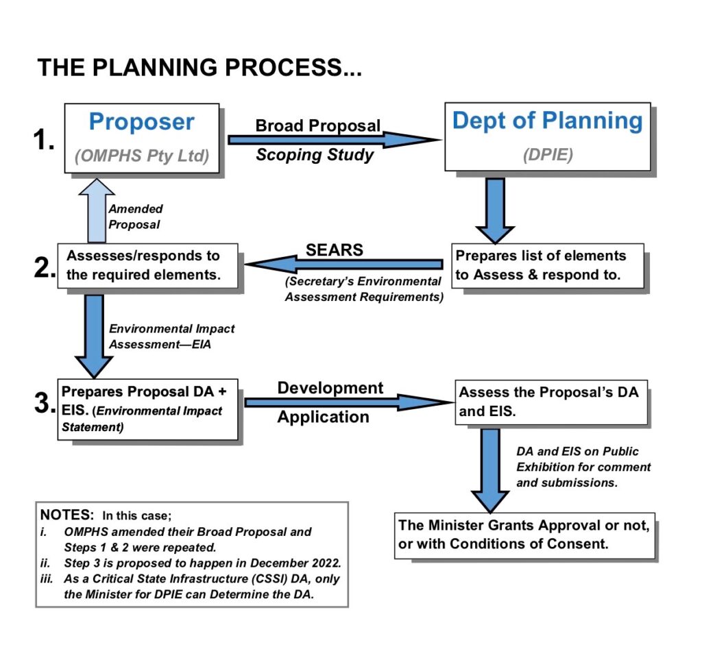
OMPHS, the proponents of the pumped hydro scheme in the Macleay Valley, lodged the EIS and DA documents with the State Government close to the elections in March 23.
Ever since, it has been a wait for the Department of Industry and Environment (DoPIE) to publish the documents and the time frame for lodging submissions (usually a minimum of 28 days are given). The SOMR Secretary has prepared sample submission letters and a list of issues to address. This material will be made available to the members and interested parties as soon as the OMPHS EIS and DA are published.
Besides the impact on the Macleay River, questions about the cost of the scheme have been raised many times. In recent weeks several articles have been published in Renew Economy comparing batteries to pumped hydro..
The Oven Mountain Pumped Hydro Scheme is part of the state significant New England Renewable Energy Zone. The massive solar and wind-turbine arrays and transmission lines on the Tablelands are dividing the community. Energy companies seem to portray the development as a ‘done deal’ as it is needed/directed by the State Government. Some community members are lobbying for a reduction of the required out-put from 8Mw to 5Mw which would lessen the impact on land, residents and cost.
Increased water use in the Upper Macleay Catchment
“Seeking water security for people and nature” is the motto of a new community group within Sustainable Living Armidale called Sustainable Water Futures Armidale Region (SWFAR). One of their first actions was to learn how Armidale Regional Council is going about planning for water security into the 2040s, and comment on this to Council.
SOMR as well as the Armidale Branch National Parks Association, are concerned that the Armidale
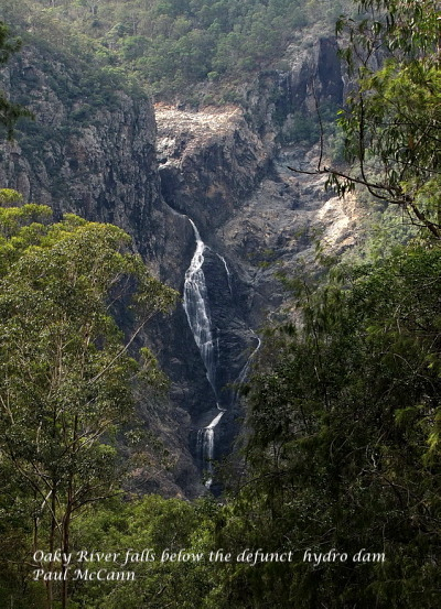
Regional Council (ARC) is not sufficiently considering the environment in its Integrated Water Cycle Management Strategy. ARC’s current preferred water security option, includes both raising Malpas dam spillway by 6.5 metres plus buying the old broken Oaky River dam, refurbishing it and constructing a 67km pipeline to pump water to Armidale (and possibly to Malpas) – at costs initially estimated at $26m for Malpas plus $108m for the Oaky scheme plus $870,000/year if 10ML/day is pumped from the Oaky.
Further concerns have been raised about the water use and run-off from water intensive horticulture industries on the Tablelands.
SOMR is seeking more information about Kempsey Shire Council’s knowledge of the impact of upriver water use on the Macleay downstream and collaboration strategies between ARC and KSC.
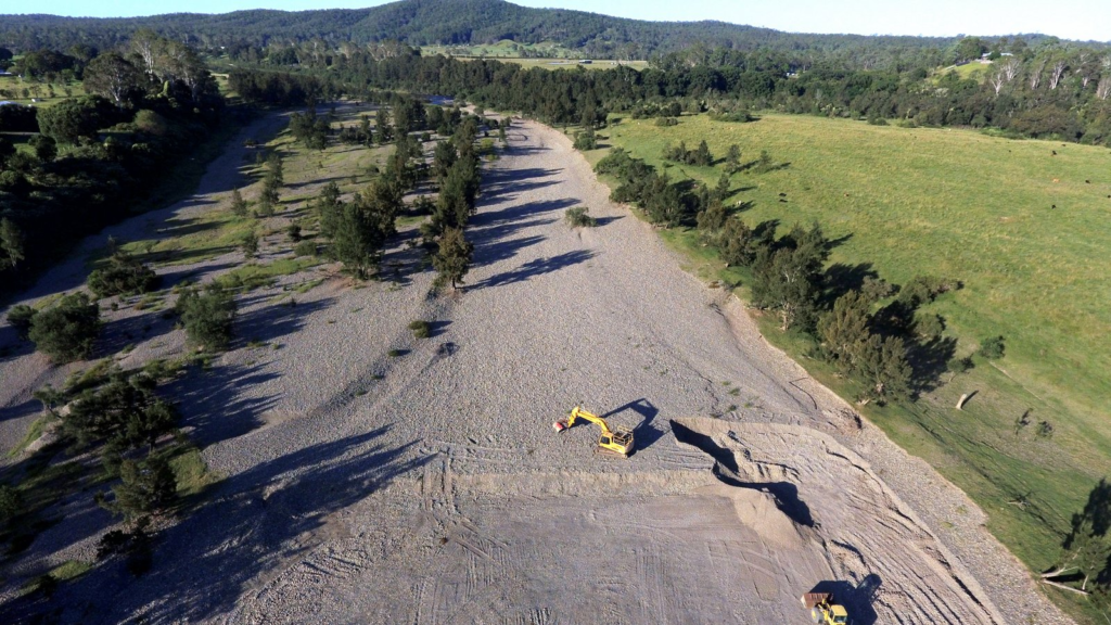
River bed gravel extraction at Turners Flat
Two extraction sites scaled up from the approved are located in an existing gravel flood-channel of the Macleay River at Turners Flat.
Every time the river rises, the channels created by the gravel extraction cause an increasing retreating nick-point and bank erosion on neighbouring properties.
The Development Approvals for the quarries were issued by Council in 1997.
A SOMR post from April 2022 describes the effects on the river in detail. (https://saveourmacleayriver.com/page/3/)
In a letter to Dept Planning Industry & Environment SOMR asked when the ‘historic’ DA and Controlled Activity Approvals and Licensing can be brought up to current standards and was advised that the Turners Flat operators are required to re-apply for ‘continuation of their Controlled Activity Approval operating conditions’ in early 2025.
SOMR members recently inspected the neighbouring site with permission of the affected property owner where extensive bank degradation can be seen.
Mining and Mining Exploration
- Hillgrove Mine, operated by Red River Resources has been in Care & Maintenance mode since Sept 2022.
- Halls Peak Mine Critical Resources Ltd (CRL) Exploration EL4474 completed exploratory drilling in 2022 described in their annual report as “administrative in nature”.
- Summit Resources’ Windfall Project’, EL 9235 some 200km² Exploration focuses on antimony at historic mines in Mungay Creek, Toorooka and well into Nambucca Shire. Several EL Access Agreements, with compensatory payments have been signed by property owners in the Mungay Creek area. No activities have been reported. The company shares an office address in WA with ‘Critical Resources’ (see Halls Peak).
Estuary Wetlands
- Yarrahapinni Wetlands
The removal of the levee for full rehabilitation of the Yarrahapinni Wetlands is still only approx 50% completed. In 2007 the task was taken on by National Parks and Wildlife Service (NPWS) from the YWR Trust with funding. The full history of the Yarrahapinni Wetlands can be found on https://saveourmacleayriver.com/wp-content/uploads/2015/09/The-Yarrahapinni-Wetlands-Story.pdf - Clybucca Wetlands Macarobinni Gates in the Clybucca Wetlands area are receiving $10,000 pa for repairs and recent concrete restoration works has been carried out by Kempsey Shire Council. SOMR will query Council as this seems to be in contradiction to an earlier Council decision not to fund maintenance for those gates.
Water Quality Monitoring
Early in February SOMR conducted a water test at Mooneba. Using the test kit, it was noted that most of the chemicals have gone past their use-by date. Unfortunately, that made the results unreliable. There is still some money from the initial fund raiser, but not enough, to purchase a new kit required to do further testing. Our attempts to secure a grant have so far been unsuccessful.
Discussions with Council about funding of water monitoring and sharing test data are ongoing.
Currently water testing is needed at Saltwater Creek in South West Rocks to monitor the impact of the adjacent land clearing for the Rise Development, however, the equipment available to Voices of SWR is also inadequate. Other options are being sought.
Illegal Dams in the Clybucca Area
According to a report in The Macleay Argus, the Natural Resources Access Regulator (NRAR) is prosecuting business owner Xiuming Lin and company Green Leaf Australia Group Pty Ltd. Each are facing two counts of building dams without approval, four counts of using dams without approval and six counts relating to illegal excavations on waterfront land. It is feared that the illegal excavations cause damage to the adjacent wetlands. The case was listed for mention in Kempsey Local Court on April 6.
Coastal Zone Management Program (CMP)
KSC has issued Expressions of Interest for the preparation of their CMP.
This is advised as being an ongoing multi -staged process, which could take some time to finalise by KS Council.
Draft North Coast Water Management Strategy
The second public exhibition ended in 2022. At the time, SOMR lodged a submission. No response has been received.
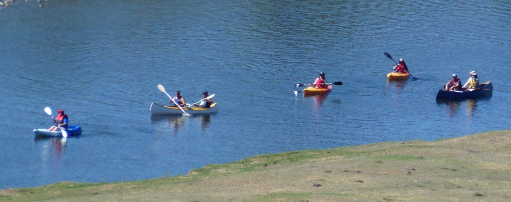
Paddle on the Macleay
On 17 September 2023, coinciding with the Gladstone Quality Markets, SOMR will organise Paddle on the Macleay in the Smithtown-Gladstone vicinity. Returning to the starting point in Smithtown, no car shuffle will be needed.
SOMR information stall will be at the Gladstone Market. The paddlers can be greeted and encouraged from the river bank.