Category Archives: SOMR Activities

Update April 2017

Now in its 4th year, Save Our Macleay River Inc is still as busy as ever attending to several issues impacting on the health of the river – banduungakayi mulumungu : from the mountains to the sea.

  • Hillgrove Mine

  • Clybucca Wetland Rehabilitation
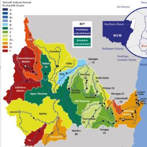
  • Ecohealth Card for the Macleay River
  • Environmental and Planning Assessment Act Amendments (EPAA)
  • Derelict Mines – Comet Vale
  • Mineral Explorations
  • Environmental Defenders Office
  • AGM

Hillgrove Mine – Clarks Gully

In 2015 Hillgrove Mines lodged a DA to expand mining operations to Clarks Gully. The site is part of the Hillgrove Mine lease. The proposed development would allow continuing mining after the orebody at the current excavation site is depleted. SOMR lodged a submission detailing concerns about the impact of the expansion on the health of the Macleay River Catchment. See post on the website archive October 2015.

18 months after submissions were lodged with the then Dumaresq Armidale Council, the application finally came before the Administrator, Ian Tiley, at the amalgamated Armidale Regional Council’s meeting on Wednesday, 1 March 2017. All of the 24 submissions received by Armidale Council were against the proposed development. At the meeting, several speakers representing the submitters expressed their concerns once again. See the SOMR presentation on the website archive March 2017 and http://www.armidaleexpress.com.au/story/4501916/council-grants-conditional-approval-for-hillgrove-mine-expansion/

After the Hillgrove Mines CEO spoke mainly about the expected economic benefits for the Armidale region, Mr Tiley issued a Deferred Commencement Development Consent. (as recommended by the Planner’s Report). This means that Hillgrove Mine needs to fulfil a number of conditions before any work at Clarks Gully can begin. While SOMR welcomes the conditions imposed, the process from now on does not allow further involvement or comment by stakeholders like the downriver communities. In consultation with Government Departments, ARC alone, will determine if, when and how the conditions are met.

SOMR members carefully considered the right to lodge a Judicial Merit Appeal, which, if successful, would perhaps have deferred the Approval. It would also have allowed all stakeholders to scrutinise and potentially object to how Hillgrove Mine meets the Conditions of Consent. However, the legal procedures appear to be too expensive for no great benefit on-the-ground. Furthermore, the 2015 State Approved Modification of Hillgrove Mines has granted an extension of time for the consolidation of approvals and licences which expires in 2019 when it is anticipated that a new DA for an Integrated and Designated Development will be required. This should give SOMR and others the opportunity to carefully scrutinise and if necessary challenge, the DA and EIS required then.

Hillgrove Mines’ representatives have offered to meet SOMR members for an update on their operations, but no date has been set.

Further information about the modification to the Hillgrove Mine can be found at http://majorprojects.planning.nsw.gov.au/index.pl?action=view_job&job_id=6901

Clybucca Wetlands Rehabilitation

As previously reported, SOMR had organised a public information event for Max Osborne from North Coast Local Land Services (NCLLS) to present the findings from the “Collombatti-Clybucca Floodplain Remediation Feasibility Study” and an update of the progress made so far to get a rehabilitation project initiated. Several farmers voiced their concerns that their grazing properties could be negatively affected by salt water. It seems unlikely that the rehabilitation measures envisaged so far could cause such inundation. SOMR understands that the farmers will have opportunities to discuss their views and will have further consultations as the planning continues.

The urgency to restore the wetlands became apparent once again when the recent heavy rains triggered the second major fish kill in 2 years. Again, estuarine fish populations were decimated and residents in the area were subjected to the stench of putrid “black water” and decomposing fish.

Downstream, the restored Yarrahapinni wetlands have become a fertile breeding ground for fish and it is sad to see them killed by the toxic water emanating from the Clybucca Wetlands. Besides the extensive fish kills, the oyster farmers in the estuary experience major loss of income at every such event. Up to 80% of their stock can be lost during the following months.

After the rain on 21 March, thousands of stressed fish at the floodgates were observed gasping at the surface. These were mostly mullet ranging from fingerlings to 15cm fish. Further downstream the main species observed at the lower end of Andersons Inlet near Yarrahapinni wetlands were bream and whiting.

Photo by Scott Anderson, DPI Fisheries

Following a similar event in early 2015, NCLLS issued a media release explaining the fish kill as a result of grasses and other plants becoming submerged, dying and rotting. “During decomposition of this organic matter bacteria consumed the oxygen in the water. In addition to this deoxygenation, a complex series of chemical reactions occur. These processes add a cocktail of chemicals to floodwaters changing acidity and heavy metal levels which can also contribute towards fishkills.” It is pointed out that the extensive network of drains and the tide restricting Menacrobinni floodgates increased the potential for and frequency of low dissolved oxygen or “black water” events.

North Coast LLS are currently helping farmers develop and implement coastal floodplain rehabilitation projects in an attempt to reduce the amount of fish kills and improve estuarine ecosystem health. NCLLS also hope to receive funding from DPI Fisheries (from the NSW Recreational Fishing Fund) to undertake further studies, community consultation and design the engineering plan required to remediate the Clybucca wetlands. If successful, this planning project will be completed by 2019.

Fishkills are not only experienced in the Macleay, but also in other rivers on the North Coast such as the Richmond. To read more about “black water” see the report about the Richmond River fish kill. Richmond River fish kill 2008

Ecohealth Card

The Kempsey Shire Council (KSC) meeting 21 Feb 2017 was presented with the long awaited Macleay River Ecohealth Technical Report 2015-2016, also known as Ecohealth Card. According to Council Minutes, it is “the first baseline dataset for water quality, freshwater, macroinvertebrates, and freshwater riparian and geomorphic condition in the Macleay catchment.”

The Macleay catchment was given an overall grading of C-,thus placed between Fair and Poor.

The report contains 6 recommendations aiming to improve the health of the river, such as replacing a causeway on Dowlings Falls Road, promoting riparian fencing, e.g. at Toorumbee, Nulla Nulla and Five Day Creek, rehabilitation of Saltmarsh at Spencers Creek. Council did not endorse the recommendations “at this stage”.

See  http://www.kempsey.nsw.gov.au/council/meetings/2017/2017-02-21/pubs/2017-02-21-minutes.pdf – item 13.10 and Appendix Q,R,S and T.

SOMR is concerned and will be contacting Council, because

  • the Macleay is obviously in rather poor health,

  • the results of the report have not been given any publicity by Council,

  • there is no indication how KSC will be working on the development of a long term catchment-wide strategy,

  • in the context of this report as well as Hillgrove Mine developments, the vital co-operation between KSC and Armidale Regional Council seems to be lacking.

Environmental and Planning Assessment Act Amendments (EPAA)

On 30 March, SOMR committee members lodged a submission objecting to the Draft Amendments to the EP&A Act. This Act governs how all Development Applications in NSW are assessed and determined.

SOMR’s objections in summary are as follows:

The proposed amendments

  • Weaken the rigor, transparency and public accountability in the Development Application Assessment and Determination process and give tremendous ‘centralised’ powers to the Planning Minister and Secretary and increase the potential for ‘doing deals’ behind closed doors.

  • Reduce the rights of the public and elected Councillors to be part of the process, and for people to express and have their concerns heard and considered.

  • Erode the requirement for EISs to be thorough and complete and challenged by the community.

  • Reduce the rights and rigor of the Judicial Merit Appeal process.

  • Do not address or take up significant opportunities to achieve good and balanced assessments of environmental benefits of strategic planning, well defined and readily administered legislation that protects the integrity of, or conserves, high value environments.

  • Do not address or include assessment of environmental costs or experienced real costs and jobs for adjacent or down-stream land-uses and industries.

  • Do not include, address or promote through an easier legislative path, restoration of historic/past approved damaging government works or approvals (e.g. ‘Flood Mitigation’ or ‘Drainage’ schemes).

To read the complete submission go to SOMR EP&A Act Submission 2017

Derelict Mines – Comet Vale

The Derelict Mines Office (DMO) NSW contracted the Port Macquarie office of the global technical consultants company GHD to compile an audit of derelict mines in the Macleay River catchment. SOMR has been advised that the report has been completed and is awaiting signing off by DMO. We understand that the findings concentrate on Kapunda and Rockvale in the upper catchment and Mungay Creek in the lower catchment.

After the site visit to the derelict mine at Comet Vale in February (see website archive February 2017), SOMR committee members have been liaising with the landholder and the Dept. of Trade and Industries. It is hoped that the stalled remediation process can soon continue. The first step will be the removal of the contaminating plastic which was brought onto the site with the mulch.

Mineral Explorations

Two companies hold mineral exploration licences (ELs) in the catchment. Both have received NSW government grants for test drilling which need to be spent by the end of June 2017.

One exploration area is at Halls Peak. SOMR has been following operations there for some years. The latest tests were done in November/December 2016. The story of the company, or rather companies, involved is almost too complicated to describe. The ELs have been shuffled from one entity to another, as have directors. From Precious Metal Resources Pty Ltd to Sovereign Gold Pty Ltd with some involvement by the Chinese company SUGEC. Most recently, Sovereign Gold was dissolved and the three ELs covering a large area in the Upper Macleay are now held by Force Commodities Pty Ltd.

One of the new directors recently visited the site. Further drilling is planned for mid-2017. See their report Force Commodity report 6 April 17

The other government grant concerns Thomson Resources Pty Ltd for gold exploration at Mt Jacob near Willi Willi. It seems that, so far, access problems have prohibited the drilling.

Environmental Defenders Office

Throughout the submission process in regards to Hillgrove Mine’s Clarks Gully DA, we were given invaluable advice by the solicitors of the Environmental Defenders Office (EDO). During recent years, EDO’s government funding has been reduced and they need donations to continue their excellent work. We encourage everybody who is concerned about the environment and about strong representation of the community to donate to EDO.  http://www.edonsw.org.au/

AGM

With so many issues to be considered and much work and vigilance needed, more hands and minds are always welcome. Membership and renewal forms can be found on this website.

Become a SOMR member and join us at the AGM

Saturday 27 May 2017, 10.30 am at Kempsey RSL

Followed by a General Meeting

Link

to an

UPDATE ON CLYBUCCA WETLANDS REHABILITATION OPPORTUNITIES

Clybucca Update Poster_2017-02-20-MSpdf

Date: Saturday March 4th – 4.30pm to 6.30pm

Venue: The Oddfellows Hall, 22 Kemp Street (opposite NORCO) West Kempsey

Presenter: Max Osborne, Senior Land Services Officer, North Coast Local Land Services

Cost: Gold coin donation

Clybucca Wetlands is a large area of land, some      10 km² kilometres or 10,000 ha, on the northern side of the Macleay River floodplain. It lies east of the hills, west of Yarrahapinni Wetlands and is divided by the new Pacific Highway dual carriageway.

   The Clybucca wetlands has been described as an “Estuarinescape Twilight Zone” by those who are exploring opportunities for its rehabilitation. The wetlands, including Mayes and Doughboy Swamps have sections which are at or below sea level, were once thriving wetlands and drought-poof refuge pastures for graziers prior to being modified by drainage, particularly in the 1960s to 70s under the extensive flood mitigation and drainage scheme.

The drainage and gates installed causes the Acid Sulphate Soils (which are found below the alluvial topsoil) to dry out during times of low rainfall. When “re-wetted” by rainwater, acid run-off along with often water containing low levels of dissolved oxygen flows into the estuary. This discharge, combined with resultant iron leachate/flock and other dissolved metals such as Aluminium, severely degrades water quality, impacting fishing and oyster industries, quality of pasture and soil health, tourism potential, and biodiversity.

Max Osborne, Senior Land Services Officer with North Coast Local Land Services, collaborating with a government inter-departmental working group, has been working towards rehabilitating this significant area of back-swamp and wetlands for the past 3 years.

SOMR encourage you to attend the presentation to see what ‘behind the scenes’ progress has been made and the opportunities for future progress.

Please support and share what is potentially a rare ‘Good News’ story, endeavouring to bring Clybucca Wetlands from the “Twilight Zone”- Back to functioning wetlands, with improved water quality, estuary dependent industries, recreational opportunities and healthy environment.

The progressive restoration of the smaller Yarrahapinni Wetlands to the east and downstream has shown that restoration is not only possible but happens relatively quickly. It is now a thriving estuarine wetland with greatly improved fish and bird habitat and with regenerating mangrove and saltmarsh Endangered Ecological Communities.

This project is supported by North Coast Local Land Services, through funding from the National Landcare Programme and Catchment Action NSW

For a print version of the poster go to Clybucca Update Poster_2017-02-20-MSpdf

Hillgove Mine News

Operations are still on hold while some exploration for viable gold deposits is carried out.

In 2015 Hillgrove Mines lodged a DA to expand mining operations to Clarks Gully. The site is part of the Hillgrove Mine lease. The proposed development would allow continuing mining after the orebody at the current excavation site is depleted. SOMR lodged a submission detailing concerns about the effects of the work on the health of the Macleay River catchment (see the post on this website October 2015) 

18 months after submissions were lodged with the then Dumaresq Armidale Council, the application will finally come before the newly amalgamated Armidale Regional Council’s meeting on Wednesday,1 March.

In preparation for the Council meeting there will be a site inspection on Monday, 27 February. Anybody who lodged a submission can attend. SOMR President Arthur Bain will speak about our concerns at the Council meeting.  


Read the presentation: SOMR Presentation to Armidale Regional Council  and reporting in the Armidale Express http://www.armidaleexpress.com.au/story/4501916/council-grants-conditional-approval-for-hillgrove-mine-expansion/

Mine rehabilitation – What do they owe the land?

On 5th February SOMR representatives visited a property in the Rockdale region near Armidale. Unsatisfactory efforts have been made to rehabilitate an unused mining lease located on a private property.

The issue was brought to SOMR’s attention because of its potential impact on the Macleay Catchment via the Wollomombi River. There are concerns about land stability, soil contaminants entering the waterways and plastic rubbish brought onto the site in poor quality mulch intended to replace topsoil.

Read more  What Do They Owe the Land